Contact
 
This email address is being protected from spambots. You need JavaScript enabled to view it.
02636 - 80 303
Mo - Fr 8.00 - 13.00 Uhr

Overview


"Vulkan-Express" gets you from river rhine to the Eifel plateau! Our track covers 18 kilometers, 400 m height difference and reaches 9 stations in the romantic Brohltal. Our stations are perfect starting points for hiking trough the "Vulkanpark Brohltal/Laacher See" and for discovering many beatiful villeages throughout the wonderful  landscape. 

Just choose the station you are interested in in the map belwo, to gather further information.


Ihr Browser kann das Objekt leider nicht anzeigen! vergrößern

Characteristics: Engeln

Wappen Kempenich

Hight: 465 m above sea level
Inhabitants: approx. 200
Homepage

Map

Ihr Browser kann das Objekt leider nicht anzeigen!   enlarge

Arrive by public transport

Bus stop:
Kempenich, Engeln Bahnhof (station)
  Search connection

Arrive by car

Address:
Geogarten am Bahnhof Engeln
56746 Kempenich-Engeln

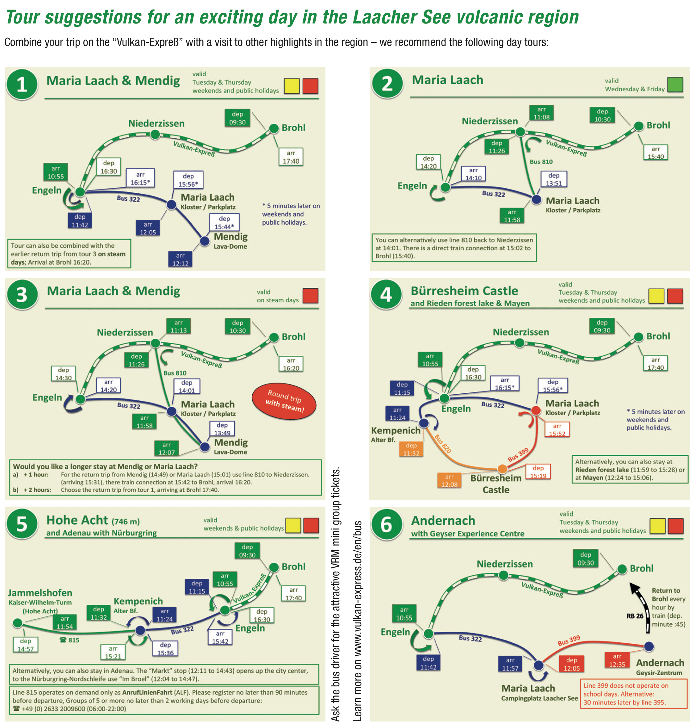
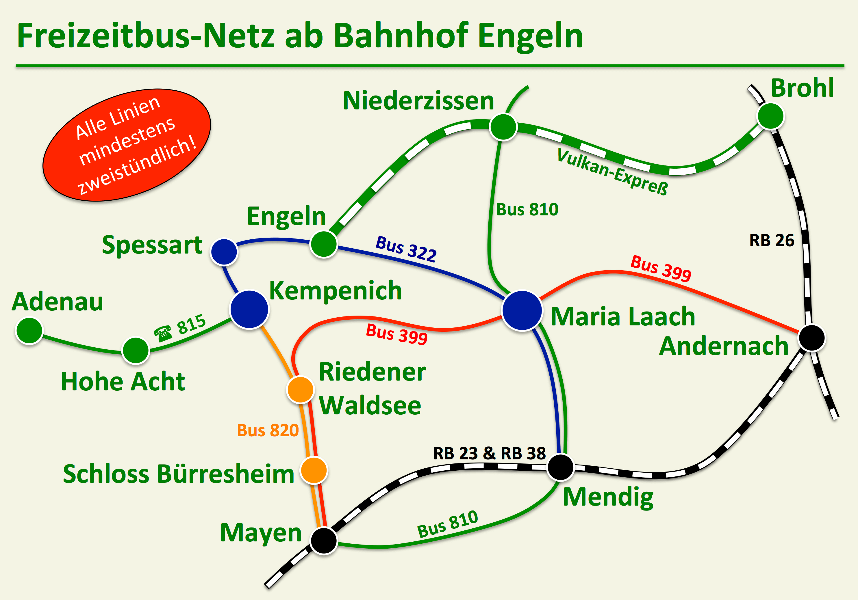
Today's tracks of Brohltalbahn end at Engeln station after 17.5 km. Since Brohl, around 400 meters in altitude have been overcome, including around 230 m on the 5.5 km long steep section between Oberzissen and Engeln. Click here for a 360 ° panorama shot. Click here for a 360° panorama.

P1070655

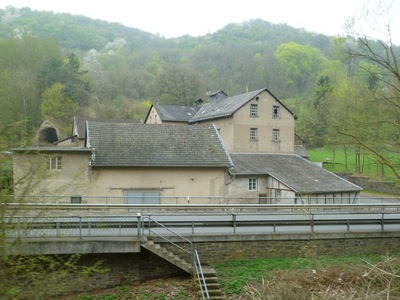
The station offers a large, catered station building built in 1997. Here the "Vulkanstube" tavern welcomes you before or after your trip with the "Vulkan-Expreß".

Until the mid-1970s, the rail line continued from here for about 6 km via Weibern to Kempenich. Unfortunately, this section was dismantled after decommissioning.

P1080087

The village Engeln is part of the municipality Kempenich and is situated above the station on the slope of the Engelner Kopf hill. With about 200 inhabitants, it is contemplative here. With its location on the Eifel plateau, Engeln offers interesting opportunities for excursions in the area and is an ideal starting point for hikes and especially for low-gradient bike tours in the direction of the Ahr valley and the Moselle. After just a few meters on foot, you can enjoy great views.

P1070646P1070635

Engeln is surrounded by the phonolite hills of the Schorberg, the Lehrenkopf and the Engelner Kopf. In contrast to the Schellkopf in Brenk, these mountains are not mined, but are part of nature reserves.

Sights around Engeln station

  • Geological garden at Engeln station

    The 1,000 m2 geological garden has been created directly in the vicinity of the station. On a circular route that starts on the platform, you will be guided through the different eras of earth's history. A special focus was placed on the volcanic past of the Eastern Eifel. Replicas of large prehistoric animals such as the Sauerier Iguanodon or a giant frog are also shown.

    Geospielgarten Engeln KN

    For children in particular, the geological garden is also a highlight thanks to a small labyrinth of hornbeam hedges and the walk-in "volcano".

  • Viewpoint over Brohltal valley

    Only 300 m from the train station you can reach a beautiful viewpoint with a great view over Olbrück Castle, Bausenberg and the Brohl Valley to the Siebengebirge near Bonn. Here you can see the great difference in height you have overcome by train!

    P1070646

    After leaving the platform, cross the tracks over the level crossing and immediately turn right again to follow the paved path parallel to the geological garden. The path is signposted as "Osteifelweg". After about 300 m you have reached your destination.

  • Village Center Engeln

    In the middle of the 1990s, Engeln's old water pump, restored by the Engeln Community Association, was installed on the village square in the center of the village. With the help of this pump, the drinking water was pumped to Engeln from the springs in the Brenker district of Fußhölle, which is much lower.

    P1080171          P1080173

    Also in the center of Engeln is the Catholic chapel of the fourteen helpers on Brenker Straße. The chapel is usually open and can be visited.

  • Brohltal outdoor pool

    Not far from the Engeln station, you can refresh yourself in Brohltal outdoor pool in summer. The pool is locaded in the middle of nature and offers an attached large lawn, a colorful water landscape, slides, flow channel and a large children's area. Even the sporty aspect is not neglected in the swimmer pool. Refreshments are available at the kiosk in the adjoining hut village. More Information

    Ahr 2Freibad Kempenich          

    The pool can be easily reached on foot after 3.4 km (approx. 55 min.), by bike via the low-gradient Brohltal cycle path after 3.8 km or on weekends by bus line 821.

    All information about the footpath can be found here:

    From Engeln station, you cycle along the almost gradient-free Brohltal cycle path. To do this, turn left directly above the train station. The path first takes you to the center of Weibern, where you cycle along the former Brohltalbahn rail tracks. At the end of the town, the cycle path changes for a few meters to the moderately trafficked country road before continuing parallel to it. Do NOT follow the access to the parking spaces of the swimming pool, but use the second access. This takes you uphill, directly along the swimming pool to the bike racks. Length of the bike route: approx. 3.8 km. The directions for the Brohltal cycle path can be found here as a PDF.

    You can also reach the pool by bus! The daily bus line 322 runs from Engeln station to Kempenich with direct connection on bus 820 to the "Weibern Freibad". From there it is only a few meters to walk.

  • Steinrausch Adventure Forest

    DSCF2376 SteinrauschThe Steinrausch adventure forest in Kempenich promises an exciting journey of discovery through nature for children and adults. The 1.7 km long nature adventure trail with 8 play and 9 information stations in an enchanted beech forest piece encourages discovery and ends with an exciting adventure playground. Adventure rallies can also be booked especially for children. More Information

    You can get from the train station to the adventure forest on foot via an approx. 5.1 km long marked hiking trail, by bike via the Brohltal bike path or by public bus.

    On foot from Engeln station, follow the signs for the "Eifelleiter" hiking path towards Kempenich. To do this, first turn left from the train station and then up through the fields south of Engeln to Engelner Kopf hill. In the forest you walk on the slope of the Engelner Kopf and then down to the Rottlandhöfe farm with its alpacas. After crossing the expressway the path leads down to Kempenich and through a residential area uphill towards Hardt. Before you cross the main road to the Nürburgring, the Eifel-Gasthof Kleefuß restaurant is on the left. After crossing the street you will find yourself at the entrance to the Steinrausch adventure forest.

    All information about the footpath can be found here:

    By bike, follow the marked Brohltal cycle path from the train station via Weibern to Kempenich. At the former Brohltalbahn train station there, leave the marked path and drive through the village via "Bahnhofstraße" until the street "Hinter der Mauer" branches off to the right. Follow this street, which soon becomes "Frankenweg" and later meets "In der Hardt". Via the latter you will reach the B 412, which you will cross and have reached your destination. Except for the last section through the village, the path is almost gradient-free. Length of the bike tour: approx. 6.9 km. You will find directions to the center of Kempenich here as PDF.

    Scheduled bus: Bus route 322 take you daily from Engeln train station to Kempenich, Alter Bahnhof. Find a bus connection. From the "Alter Bahnhof" bus stop, the footpath is as described above for cyclists.

For those discovering the Laacher See volcanic region, we offer attractive combinations of a trip on the "Vulkan Express" and a visit to other tourist highlights!

Combine your nostalgic train journey through the Brohltal with a visit to the Laacher See with the well-known Maria Laach Monastery, to Bürresheim Castle or to the Lava Dome volcano museum with the neighboring Vulkan brewery in Mendig! The unique cold water geyser near Andernach and the "Roof of the Eifel", the Hohe Acht, are also easily accessible by bus.

The frequent bus services from our Engeln and Niederzissen train stations make it possible! Operating daily every hour or every two hours, the modern buses of Verkehrsbetriebe Mittelrhein (VMR) will take you to other exciting destinations! You can easily get the tickets from the bus driver - ask for the attractive mini group tickets of the Verkehrsverbund Rhein-Mosel (VRM)!

Tour suggestions for an exciting day in the Laacher See volcanic region

230224 Leporello 2023 EN final Web Busgrafiken

The graphics each show a full-day excursion. You can see the validity of the respective tour suggestion in the header at the top right.

You can find more information about the excursion destinations here.

Bus line overview

Engeln station

220304 BusnetzDuring the summer months, the VMR bus line 322, which is linked to the "Vulkan-Express", runs daily from Engeln train station to interesting destinations in the volcanic region:

  • Line 322 "Freizeitbus Vulkanpark": The line takes you every two hours Monday to Friday and every hour on weekends to the Laacher See with the Maria Laach Monastery and to Mendig (Vulkan Brewery, Lava Dome and train station with train connections to Koblenz). If you change to line 810 at Laacher See, you can also get to Niederzissen and Sinzig. Timetable

Niederzissen station

At the Niederzissen train station you can also change to hourly or every two-hourly bus routes through the volcanic region and thus reach other destinations:

  • Regiobus line 800: Daily at regular intervals (Mon-Fri every hour, Sat/Sun every two hours) the Regiobus 800 runs from Niederzissen train station in the direction of Königsfeld, Ramersbach and Bad Neuenahr-Ahrweiler. This line is therefore ideal for planning your tours in the direction of the Ahr Valley. Timetable
  • Regiobus line 810: Line 810 takes you regularly to the Sinzig train station as well as to Maria Laach, Mendig and Mayen. By changing to line 322 at Laacher See you can also reach our Engeln train station. Timetable

Find more informations and detailed timetables at Verkehrsbetrieben Mittelrhein (VMR) or Verkehrsverbund Rhein-Mosel (VRM).

Steckbrief: Brohl-Lützing

Wappen Brohl

Höhe: 70 m ü. NN
Einwohner: ca. 1450
Homepage

Lageplan

Ihr Browser kann das Objekt leider nicht anzeigen! vergrößern

Anreise mit dem ÖPNV

Zielhaltestelle:
Brohl-Lützing, Bahnhof
Verbindung suchen

Anreise mit dem Auto

Adresse:
Koblenzer Straße
56656 Brohl-Lützing

In den Brohler Rheinanlagen befindet sich ein kleiner Haltepunkt im Verlauf der Hafenbahn.

D1P Ausf. Brohl Rheinanlagen geschoben 14.07.17

Angefahren wird er allerdings nur zur Bedienung des Schiffsanlegers. Wenn Sie mit einem Schiff anreisen, haben Sie hier die Möglichkeit, direkt in den „Vulkan-Expreß“ umzusteigen. Die regelmäßig befahrene Strecke des „Vulkan-Expreß“ beginnt am Bahnhof Brohl BE.

Steckbrief: Brohl-Lützing

Wappen Brohl

Höhe: 70 m ü. NN
Einwohner Ortsteil Brohl: ca. 1.450
Homepage

Lageplan

Ihr Browser kann das Objekt leider nicht anzeigen! vergrößern

Anreise mit dem ÖPNV

Zielhaltestelle:
Brohl-Lützing, Bahnhof
Verbindung suchen

Anreise mit dem Auto

Adresse:
Bahnhofstraße
56656 Brohl-Lützing

Der Bahnhof Brohl BE ist das Herzstück unserer Schmalspurbahn ins Brohltal. Am südlichen Ortsrand, direkt gegenüber des DB-Bahnhofs Brohl gelegen, bietet die Station nicht nur ideale Voraussetzungen zur An- bzw. Weiterreise mit den Zügen der MittelrheinBahn, sondern auch kurze Wege zum Rhein und in das Ortszentrum.

20150605 BTE 1440 121 5875

Brohl gehört heute mit dem Ortsteil NIederlützingen zur Ortsgemeinde Brohl-Lützing in der Verbandsgemeinde Bad Breisig. Der direkt am Rhein liegende Ortsteil Brohl verdankt seine Entstehung der verkehrsgünstigen Lage. Schon die Römer legten in Brohl einen ersten Hafen an, der für den Abtransport der in der Umgebung gewonnenen Vulkangesteine genutzt wurde. Mit dem Bau der linksrheinischen Eisenbahnstrecke gewann der Ort als Industriestandort weiter an Bedeutung.

P1060845

Nach der Eröffnung der Brohltalbahn wurde der Hafenbetrieb und Güterumschlag stetig ausgeweitet. Auch vor Ort ansässige Unternehmen prägten seit dem Beginn der Industrialisierung das Ortsbild. Eine große Bedeutung für den Ort hat die sehr bekannte Mineralquelle mit der etablierten Marke „Brohler“.

Für die Brohltalbahn war Brohl seit jeher der Betriebsmittelpunkt. Mit den umfangreichen Werkstatt- und Bahnbetriebsanlagen sind hier noch heute die Fahrzeuge des Vulkan-Expreß zu Hause. Neben dem Personenbahnhof werden ein großer Umladebahnhof zu den DB-Gleisen und eine Anschlussstrecke in den Rheinhafen betrieben. Gegenüber des Lokschuppens liegt das ehemals ebenfalls zur Brohltalbahn gehörende Busdepot der Ahrweiler Verkehrs-GmbH.

Nähere Infos zu Brohl.


Ausflüge ab dem Bahnhof Brohl


  • Schiffsanleger & Rheinanlagen

    Zwischen dem Sportplatz und dem Hafen befinden sich östlich der Bundesstraße 9 die Brohler Rheinanlagen. Spazierwege am Rhein entlang und auf die Hafenmole sowie ein kleiner Imbiss laden zum Verweilen ein.

    Hier befindet sich auch der liebevoll restaurierte Aalschokker „Katharina“, der in ehrenamtlicher Arbeit durch den Brohler Kulturverein hergerichtet wurde und nun in den Rheinanlagen an die Fischfang-Geschichte von Brohl erinnert. Nähere Infos.

    Brohl - Tor zum Brohltal          Vulkan-Expreß Aalschokker

    Direkt an den Rheinanlagen betreibt die Brohltalbahn einen Schiffsanleger, der im Sommer insbesondere von der "MS Beethoven" angefahren wird. Über den Haltepunkt Brohl Rheinanlagen holen wir die Schiffsfahrgäste direkt mit dem Vulkan-Expreß am Anleger ab.

  • Burg Brohleck

    P1070609

    Am westlichen Ortsrand, am Berghang zum Brohltal hin, befindet sich die Burg Brohleck. Die 1289 erstmals urkundlich erwähnte Burg befand sich meist in Familienbesitz. In jüngster Zeit ist die Anlage für verschiedenste Veranstaltung öffentlich zugänglich. Zahlreiche Konzerte und der jährliche Weihnachtsmarkt im Burghof vermitteln eine ganz besondere Stimmung. Nähere Infos


  • Ortszentrum mit Pfarrkirche „St. Johannes der Täufer“

    Im Ortszentrum von Brohl finden Sie neben dem am Dorfplatz gelegenen Rathaus die 1891 fertiggestellte katholische Pfarrkirche „St. Johannes der Täufer“.

    BrohlRathaus klein          BrohlKirche klein

  • Aussichtspunkt über Brohl

    P1060854Oberhalb des Bahngeländes der Brohltalbahn finden Sie im Hang eine kleine Kanzel. Von dort und von verschiedenen weiter oben gelegenen Ruhebänken haben Sie einen tollen Ausblick über Brohl und das Rheintal.

    Sie erreichen den Aussichtspunkt, indem Sie vom Bahnhof kommend entlang der Gleise zum Lokschuppen gehen. Dort finden Sie linkerhand eine kleine Treppe, der Sie aufwärts folgen und anschließend auf den dortigen Bahnübergang mit der Straße Am Dicktberg zugehen. Dort treffen Sie auf die Wandermarkierung des Rheinburgenwegs (Markierung "R"). Folgen Sie dieser über den Bahnübergang hinweg auf einem schmalen Pfad bergauf. Nach wenigen hundert Metern erreichen Sie die kleine Kanzel.

Steckbrief: Schweppenburg-Heilbrunnen

Wappen Brohl

Höhe: 80 m ü. NN
Einwohner: ca. 10

Lageplan

Ihr Browser kann das Objekt leider nicht anzeigen! vergrößern

Anreise mit dem ÖPNV

Zielhaltestelle:
Schweppenburg, Brohl-Lützing
Verbindung suchen

Anreise mit dem Auto

Adresse:
Schweppenburg
56656 Brohl-Lützing

Im unteren Brohltal befindet sich nach rund 3,3 km Fahrt der Bedarfshaltepunkt „Schweppenburg-Heilbrunnen“. Die namensgebenden Bestandteile der Bezeichnung befinden sich in unmittelbarer Umgebung des idyllisch gelegenen Haltepunkts. Jenseits der Brohltalstraße erblickt man auf einer Anhöhe die Schweppenburg, die sich im Privatbesitz einer Kölner Adelsfamilie befindet. Gleich neben der Burg liegt die Mosenmühle, in der noch heute mit Wasserkraft Korn zu Mehl gemahlen wird.

DSC02692 Kopie

Geht man vom Haltepunkt aus in die andere Richtung, so gelangt man auf die von zwei großen Steinkugeln bewehrte Zufahrtsstraße zum Tönissteiner Mineralbrunnen. Nach wenigen hundert Metern steht man vor den Werkstoren des weltbekannten Brunnens.

Da der Haltepunkt ein Bedarfshalt ist, melden Sie sich zum Aussteigen bitte rechtzeitig, d.h. spätestens vor der Abfahrt in Brohl bzw. Bad Tönisstein beim Zugpersonal. Zum Einsteigen genügt es, sich gut sichtbar auf dem Bahnsteig aufzustellen.

Ausflüge ab dem Haltepunkt Schweppenburg-Heilbrunnen

  • Schweppenburg

    Vom Haltepunkt aus kann man die um 1365 erbaute Schweppenburg auf der anderen Seite des Brohlbachs und der Brohltalstraße bereits erkennen. Während eines Umbaus im 17. Jahrhundert erhielt die Burg ihr heutiges Gesicht im Stile des Barock. Leider muss man sich mit der Betrachtung der Anlage von außen begnügen. Die in Privatbesitz der Kölner Patrizier-Familie von Geyr befindliche Burg kann leider nicht besichtigt werden. Nähere Infos

    DSC02695 Kopie

  • Mosenmühle

    Direkt unterhalb der Schweppenburg befindet sich die Mosenmühle. Hierbei handelt es sich um eine traditionelle Wassermühle, in der Müllermeister Mosen noch heute mittels Wasserkraft Korn zu Mehl mahlt. Ursprünglich als Öl- und Getreidemühle erbaut wurde die im 14. Jahrhundert erstmals erwähnte Mühle im 19. Jahrhundert auch als Mühle für das im unteren Brohltal häufig vorkommende Vulkangestein Trass genutzt. Noch heute wird die Mosenmühle intensiv als Getreidemühle genutzt. Das Wasser des Brohlbachs treibt dazu das aus dem Jahr 1912 stammende, etwa 7 Meter messende Wasserrad an, das die Kraft über Transmissionsriemen auf das Mahlwerk überträgt.

    Mosenmühle

    Angeschlossen an die Mühle ist ein Mühlenladen in dem die hier produzierten Produkte direkt beim Erzeuger erworben werden können.

    Nach Voranmeldung kann die Mühle besichtigt werden. Nähere Infos finden Sie auf der Homepage der Mosenmühle.

  • Tönissteiner Mineralbrunnen

    Nicht weit vom Haltepunkt entfernt liegt in einem Seitental des Brohltals, dem Pönterbachtal, die Abfüllanlage des bekannten Tönissteiner Mineralbrunnens. Der schon den Römern bekannte Brunnen zeichnet sich durch sein besonders mineralstoffreiches Wasser aus, das aus bis zu 652 m Tiefe gewonnen wird.

    P1060867          DSC02690 Kopie

    Auf der rechten Seite des Werksgeländes haben Sie die Möglichkeit, an einem an der Außenwand befestigten Wasserhahn kostenlos das belebende Mineralwasser zu probieren. Nähere Infos

We use cookies on our website. Some of them are essential for the operation of the site, while others help us to improve this site and the user experience (tracking cookies). You can decide for yourself whether you want to allow cookies or not. Please note that if you reject them, you may not be able to use all the functionalities of the site.